Section 2 (4-5 days)
Geelong to Aireys Inlet 95km
Geelong to Ocean Grove
There are two (2) ways to travel this section:
A: One day direct to Ocean Grove (26km), or;
B: Two or three day option through Queenscliff.
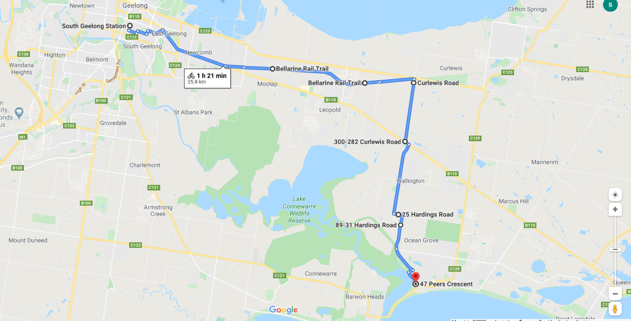
A: One Day direct (26km)
Terrain: Depart Geelong from the South Geelong Railway Station. The Bellarine Rail Trail technically begins here but it doesn't show up on mapping until the Geelong Showgrounds. Pick up the trail at the end of the South Geelong station carpark to the east Travel about 14km along the trail before turning south. Consisting mostly of open farmland then along some rural roads to the first glimpse of the ocean. Unfortunately after leaving the rail trail there are a couple of stretches of roadway without designated pedestrian access that can at times carry a bit of traffic. However, there is in the most part a wide grassy verge for walkers.
Shorten: Take the No.56 bus towards Queenscliff along the Bellarine Highway and get off at any of the numerous stops. 10-12 per day timetable available here. www.railmaps.com.au/routedetails.php?RouteSelect=1421
Click here to download detailed directions (PDF)
A: One day direct to Ocean Grove (26km), or;
B: Two or three day option through Queenscliff.
A: One Day direct (26km)
Terrain: Depart Geelong from the South Geelong Railway Station. The Bellarine Rail Trail technically begins here but it doesn't show up on mapping until the Geelong Showgrounds. Pick up the trail at the end of the South Geelong station carpark to the east Travel about 14km along the trail before turning south. Consisting mostly of open farmland then along some rural roads to the first glimpse of the ocean. Unfortunately after leaving the rail trail there are a couple of stretches of roadway without designated pedestrian access that can at times carry a bit of traffic. However, there is in the most part a wide grassy verge for walkers.
Shorten: Take the No.56 bus towards Queenscliff along the Bellarine Highway and get off at any of the numerous stops. 10-12 per day timetable available here. www.railmaps.com.au/routedetails.php?RouteSelect=1421
Click here to download detailed directions (PDF)

From Geelong
|
To Ocean Grove
(53m-4m) |
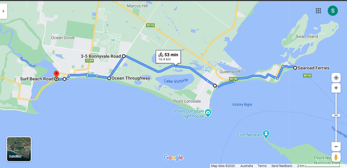
B: Two/three day through Queenscliff (55km)
Follow the Bellarine Rail Trail using the map available here. Accommodation is available at Leopold (11km); Drysdale/Clifton Springs area (7/10km) and; Queenscliff/Point Lonsdale (17/20km).
Leaving Queenscliff, it is possible to walk along the beach or through foreshore reserves pretty much all the way through Point Lonsdale to Ocean Grove so this has not been shown on a map. However, for cyclists there is an alternative map provided.
Click here to find out what facilities and accommodation are available in the towns.
From Queenscliff |

|
To Ocean Grove
|
Points of interest:
Bellarine Rail Trail: Shared cycle and walking trail on the site of the old Geelong to Queenscliff rail line. It meanders through mostly rural country, passing through the towns of Leopold and Curlewis.
Lake Coonewarre Wildlife Reserve: Bird and wildlife sanctuary but you will need to detour to visit it. Coonewarre comes from Koonnoowarra, meaning the black swan.
Barwon River: An iconic river system of Victoria, 160km long and flows through Geelong to meet the sea at Barwon Heads.
Water Views: First glimpse of the Ocean.
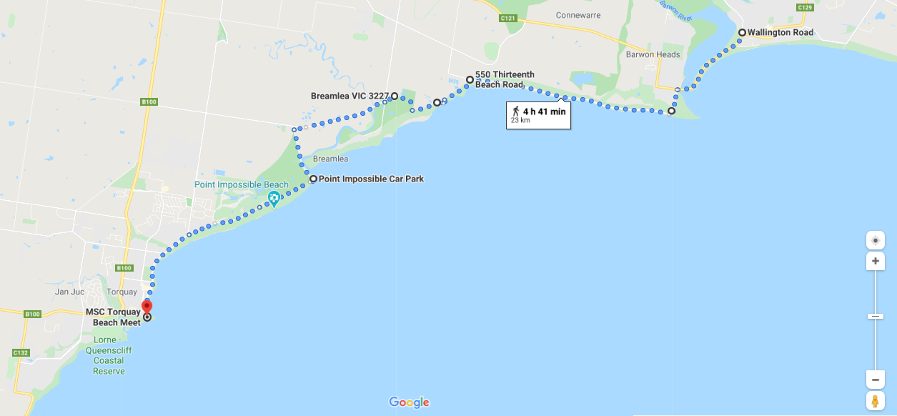
Ocean Grove to Torquay 23km
Terrain: This section includes beaches, dunes and some walking tracks which at times are not clearly indicated so the map shows the cycling route. Depart Ocean Grove across the bridge over the Barwon River to another seaside hamlet, Barwon Heads. There are many options of walking trails to the lookout point of Barwon Heads Bluff. Or you can follow the road which becomes Thirteenth Beach Road. Once past this rocky cape take any set of stairs to the beach as it is possible to walk a large part of this walk along the beaches. The sand is generally very hard packed and not difficult. At high tide don't attempt any rocky outcrops. There are many exit points from 13th beach out to the roadway. At the Waste Water Outfall Plant the track disappears into the sand dunes. It is possible to walk through this and rejoin the beach on the other side but it is difficult with very soft sand, steep dunes and no designated path. The best alternative is to take the well made bike path on the north side of the plant. Locate the bike path at the intersection of Blackrock Road and Thirteenth Beach Road.
The map and directions for this section takes you around the back of Breamlea, but it is possible to walk the beach, as at the west end of Breamlea beach the Thompson Creek can be crossed at low tide. It is not a very deep creek even during other tide times. Once crossing the creek there is a path up to Point Impossible. However, it is recommended you check the tide times before walking to the end of Breamlea. If unable to cross, it will be necessary to follow the cycling option below.
Shorten 5km: Take bus No.55 from Wallington Rd, Ocean Grove, to just over the bridge in Barwon Heads. Timetable available here. mcharrys.com.au/timetable/route-55-geelong-to-ocean-grove-via-barwon-heads/#!
Cycling: The first part is along Thirteenth Beach Road (about 7km) that turns into the Black Rock Bicycle Trail which takes you almost into Breamlea. Unless you want to visit Breamlea stay on Blackgate Road north of Breamlea as there is no cycle access through Breamlea. At Point Impossible Rd turn south (left) towards the sea. At Point Impossible you will commence the Surf Coast Trail which is suitable for bikes and this will take you into Torquay.
Click here to download detailed directions (PDF)
Mostly flat with very little gradient change.
Points of interest:
Barwon River: An iconic river system of Victoria, 160km long and flows through Geelong to meet the sea at Barwon Heads.
Brimlea: Before European settlement it is told that the local tribe, the Wathaurrong, migrated down Thompsons Creek (formally Bream Creek) during summer to harvest food from the sea.
Coastal dune systems: The area is of much environmental significance with wetlands, sand dunes and saltmarsh.
Surf Beaches: Barwon Heads, Breamlea and Torquay beaches.
Surf Coast Walk: After Breamlea, at Point Impossible, the route is the signposted Surf Coast Walk which is followed through Torquay, Anglesea and finishes in Aireys Inlet.
Ocean Views: From Zeally Bay point near Barwon Heads beach.
Click here to find out what facilities and accommodation are available in the towns.
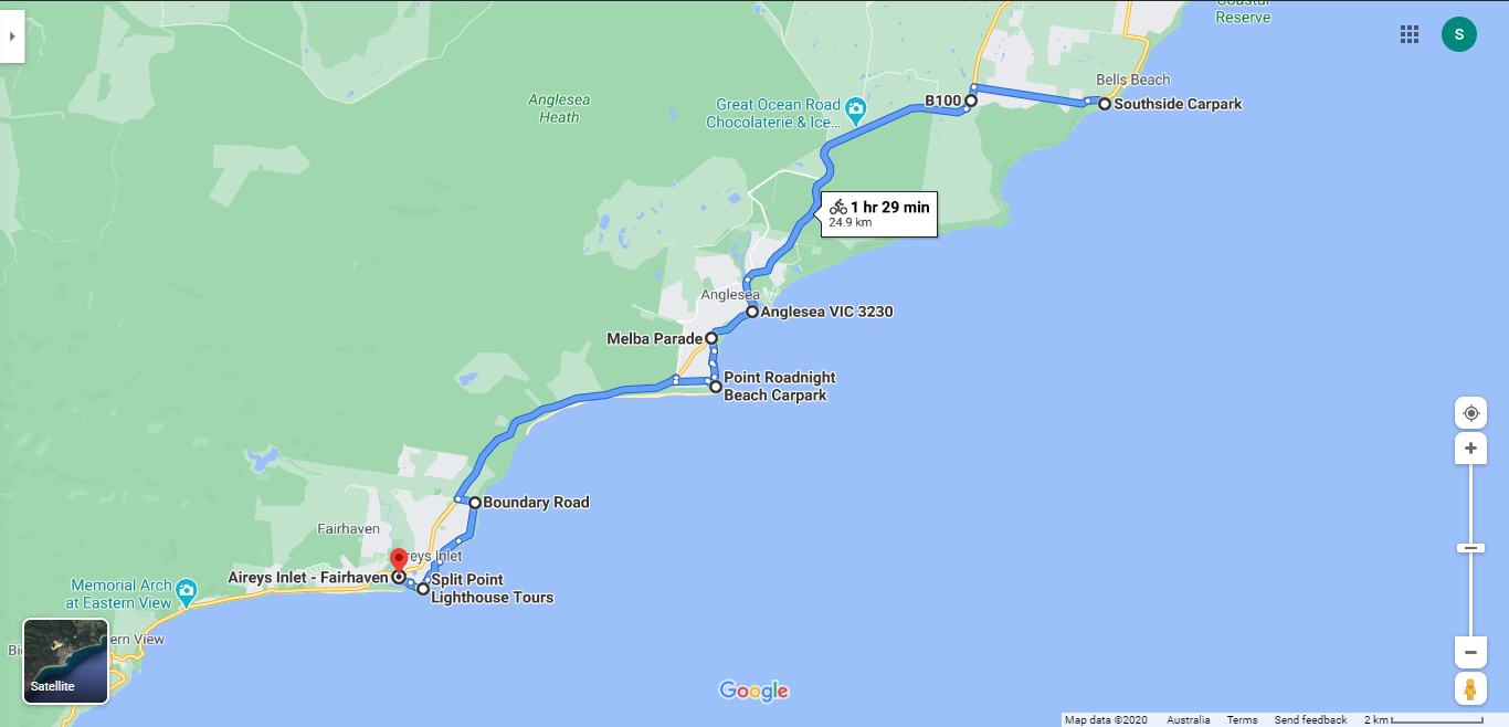
Torquay to Aireys Inlet 40km (via Anglesea-25km)
Terrain: The major part of this section is on the signposted Surf Coast Walk, a designated walking trail between Point Impossible and Aireys Inlet. https://www.surfcoastwalk.com.au/sites/default/files/surf_coast_walk_a2_map.pdf It consists of mostly fine gravel or compacted earth with some sections of sand or sealed roads. Some sections of this trail can be cycled, but not all. The map provided below is for the section of the Surf Coast Walk that is not suitable for cycling. See cycling section below for more detail.
Shorten: Take the bus from Torquay Caravan Park and get off at any of the 10 stops along the Great Ocean Road between Torquay and Aireys Inlet. Operates about 6-7 per day and takes about 50 minutes.
Cycling: The Surf Coast Trail is shared-use for some sections. Cycling is permitted from the start point at Point Impossible all the way through to Ironbark Basin car park, to the north of Point Addis. Other sections are designated walker-only. For the sections of this trail that are not dual use, ie not open to cyclists, it will be necessary to cycle on both the C132 and the Great Ocean Road. You can pick up the C132 at Bells Beach and follow this until the B100 (Great Ocean Road). The Great Ocean Road in this section, whilst carrying heavy traffic at times, it has wide paved verges and in some parts marked cycle ways. Extreme caution needs to be taken on all roads carrying traffic.
Click here to download map of the Surf Coast Walk (PDF)

From Torquay
|
To Aireys Inlet
(105m-4m |
Points of interest:
Surf Coast Walk: Explore traditional Wathaurung Aboriginal country, windswept sand dunes, and coastal vegetation.
Guided Surf Coast Walk: Led by a member of the Wathawurrung people, this tour will allow you to explore and learn about aboriginal culture of the area including midden, ochre sites and much more. Run twice a year and bookable (in advance) at Torquay Caravan Park - a three day program, including accommodation and a guided walk with an aboriginal leader, exploring and learning about the Wadawurrung people of this region. This experience will offer you a better cultural understanding of this beautiful coastline. https://torquaycaravanpark.com.au/specials/guided-surf-coast-walk/
Bells Beach: one of Australia's famous surfing beaches and home to the Rip Curl Pro held every Easter.
Point Addis: Koori Interpretational walk.
Ironbark Basin: Explore the inland sheltered forest of the Ironbark Basin in the Great Otway National Park. See grasstrees, rare orchids (in season) and other flora and fauna.
Anglesea: A small coastal hamlet with restaurants and coffee shops.
Anglesea Art Walk:. A guidebook is available at the Anglesea Visitor Centre for the 2.5km walk starting at Loveridge Lookout.
Views: Look out from Point Addis and Rocky Point to the surf breaks, sheltered bays and wild headlands.
Click here to find out what facilities and accommodation are available in the towns.
