Section 3 (6-7 days)
Aireys Inlet to Princetown 150km
At this point in time this section is a bit problematic. There is no really safe way to walk or cycle to Apollo Bay to meet up with the Great Ocean Walk as currently the only road along this stretch is the Great Ocean Road (GOR). The GOR is narrow and winding in some sections with little to no verge and at times it carries quite a bit of traffic including tourist buses. In saying this the road is used regularly by cyclists so should you wish to continue along the coast through Lorne to Apollo Bay please read the information provided in the special section at the end of this page (after Princetown).
There are several different ways to undertake this section:
IMPORTANT SAFETY INFORMATION: If you are a solo walker, it is recommended that you stop at Aireys Inlet and take the bus as the next few stages can be a bit remote and through forests and bushland. All safety recommendation and advice is to not walk alone in the Australian bush at any time of year. Please read the Safety page before departing on this walk.
There are also less accommodation options and very few services over the next 100+km, from here to Princetown, so if you are not able to advance book accommodation at any point, then take the bus from Aireys Inlet. There are also sections where there is no alternative but to walk on the GOR. Whilst these sections of the GOR are less winding and narrow than earlier sections, and there is in some instances a substantial grassy verge, extreme caution is definitely required. When walking on any roads and not designated walking or bush tracks extreme caution is required as logging trucks and tour buses may use these roads. The route climbs rises to an elevation of about 500m in this stage and includes a lot of ups and downs.
There are a number of waterfalls in the Otway Ranges, but you will need to detour to visit them.
The Otway National and Forest Parks contain more than 100 registered Aboriginal heritage places, but this is likely a small percentage of the cultural sites that exist in the region. Extract from https://otwaylifemagazine.wordpress.com/2014/05/30/forrests-aboriginal-heritage-past-and-continuing/
There are several different ways to undertake this section:
- Take a bus to Princetown and resume walking from there. One bus daily with change at Apollo Bay - journey time of about 3hrs. https://www.ptv.vic.gov.au/journey/
- Take the bus to Apollo Bay. Three bus services to Apollo Bay per day with a journey time of 1.5hrs. https://www.ptv.vic.gov.au/journey/ and contact a tour operator (Great Ocean Road Shuttle P: 03 52 379 278
M: 0428 379 278 or https://walk91.com.au/ Ph. + 61 3 5237 1189) to organise a walk along the Great Ocean Walk. - From Apollo Bay organise your own walk along the Great Ocean Walk. It is possible to do this without having to carry a pack by booking accommodation in Marengo (5km), Cape Otway (23km), Glen Aire (15km), Johanna (12/15km), Wattle Hill (17km) and Princetown (15km)....some sections are difficult with steep ups and downs.
- Look at https://www.hike2camp.com.au/ Mob: 0497132047 to see if you can fit in with one of their 4-6 day supported hikes along the Great Ocean Walk starting in Apollo Bay. (Tented accommodation with no showers). Three bus services to Apollo Bay per day with a journey time of 5hrs. https://www.ptv.vic.gov.au/journey/
- Look at https://walk91.com.au/ Ph. + 61 3 5237 1189 to organise a tour of 3-7 days or a shuttle.
- Contact Ride with us to arrange shuttle service. www.ridewithus.com.au 0438 407 777
- Follow the walk information provided here from Aireys Inlet into the Otways. This section is very difficult and recommended for experienced walkers only. It is not recommended for solo walkers at any time of the year as sections are quite remote and in some difficult terrain. If choosing to walk this stretch it is strongly recommended to carry a Personal Location Device (PLD). Please note this alternative also requires some stretches on the Great Ocean Road.
- The route through the Otways is suitable for cyclists.
IMPORTANT SAFETY INFORMATION: If you are a solo walker, it is recommended that you stop at Aireys Inlet and take the bus as the next few stages can be a bit remote and through forests and bushland. All safety recommendation and advice is to not walk alone in the Australian bush at any time of year. Please read the Safety page before departing on this walk.
There are also less accommodation options and very few services over the next 100+km, from here to Princetown, so if you are not able to advance book accommodation at any point, then take the bus from Aireys Inlet. There are also sections where there is no alternative but to walk on the GOR. Whilst these sections of the GOR are less winding and narrow than earlier sections, and there is in some instances a substantial grassy verge, extreme caution is definitely required. When walking on any roads and not designated walking or bush tracks extreme caution is required as logging trucks and tour buses may use these roads. The route climbs rises to an elevation of about 500m in this stage and includes a lot of ups and downs.
There are a number of waterfalls in the Otway Ranges, but you will need to detour to visit them.
The Otway National and Forest Parks contain more than 100 registered Aboriginal heritage places, but this is likely a small percentage of the cultural sites that exist in the region. Extract from https://otwaylifemagazine.wordpress.com/2014/05/30/forrests-aboriginal-heritage-past-and-continuing/
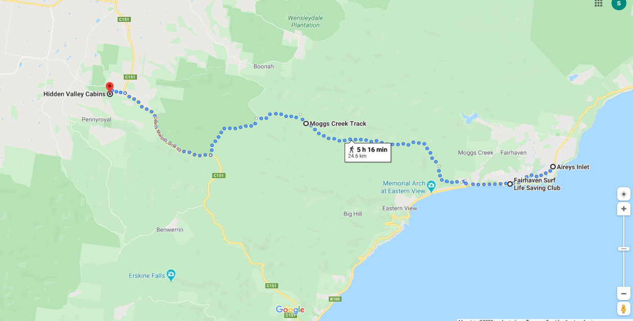
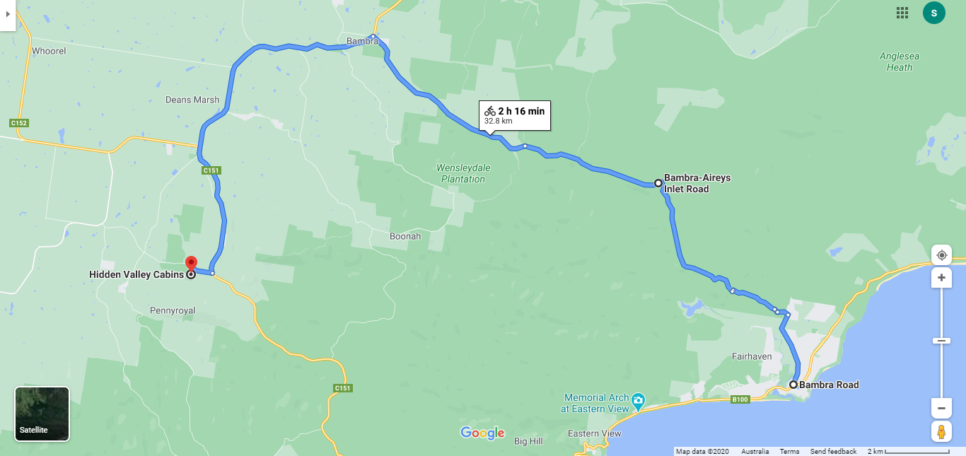
Aireys Inlet to Pennyroyal 26km
Please note, this section has not been trialed or proven.
Terrain: Steep ascents, hilly and mostly unmade roads but also lovely walking through the Otway National Park. Mobile phone coverage can be intermittent and inconsistent throughout the Otways. According to Parks Victoria, Moggs Creek Track is a seasonally gated road and is very rough and steep in parts. The surface may vary with weather conditions so please check with local authorities before departure. There are no shops, facilities or water available. There is also a section of about 2-3km on the Deans Marsh Lorne Road - a busy road with very little verge.
Shorten: There are no public transport options, but there is a taxi service operating out of Anglesea. Mob: 0408 325 992 or shuttle service with www.ridewithus.com.au. Or talk to your accommodation about options.
Cycling: Cyclists will need to follow a completely separate route in this section as many of the tracks are impassable on a bike. Follow the route outlined in the map below the walk route. This route is a bit longer (34km)
Aireys Inlet was known to the aboriginals pre-colonisation as Managwhawz. Wikipedia
Click here to download detailed directions (PDF)

From Aireys Inlet
|
To Pennyroyal
(6m-444m) |
Points of interest:
Views: Over the ocean for miles.
Otway Ranges National Park: A mostly off-road experience through the coastal ranges and could be quite challenging.
Aireys Inlet Lighthouse: Take a detour to visit the stunning Split Point lighthouse which helps to guide ships and other craft along the Victorian coast between Cape Otway and Point Lonsdale. There are guided tours and you can walk to the top up the narrow stairs. The lighthouse is known affectionately to the locals as ‘The White Queen’ as a result of its stark white façade.
Lighthouse Discovery Trail: This coastal walk will take you past prime whale-watching lookouts, and through an ancient tribal boundary line between the Wathawurrang and Gadubanud mobs. check for link???
Eagle Rock Marine Sanctuary: 17 hectares of ocean waters off the shore of Aireys Inlet including Eagle Rock and Table Rock, two limestone stacks that jut out of the water. At the sanctuary, you might even come across the remnants of ‘middens’ - ancient Aboriginal cooking sites which are over 2000 years old.
Click here to find out what facilities and accommodation are available in the towns.
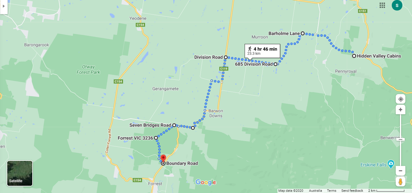
Pennyroyal to Forrest 25km
Terrain: Consisting mostly of quiet country roads, both sealed and unsealed through bushland and open farms. Fairly flat after leaving Pennyroyal. This route has been mapped from one of the accommodation places in the area so you may have to do some re-routing depending on the location of your accommodation.There are many turns in this section so take care with the directions or mapping device. Mobile phone coverage can be intermittent and inconsistent throughout the Otways. No shops or other services at all so make sure you have enough water and your telephone is charged. The last section is through an area designated as the Forrest Yaugher Mountain Bike trails. However, there is also a trail called Tiger Loop which runs parallel to the main road into Forrest beginning at the junction of Birregurra Forest Rd and Seven Bridges Rd that you may choose to take as an alternative.There is also one small section of main road so take care with traffic including logging trucks.
Shorten: There are no public transport options, but there is a taxi service operating out of Colac. Ph. 132227. Or talk to your accommodation about options.
Cycling: Follow the route outlined.
The earliest inhabitants of the area now known as Forrest were from the Gadubanud and Gulidjan language groups, who moved along trading routes and story lines in the area. Many Aboriginal heritage places are registered in the area and some local Aboriginal family groups trace their heritage to before European settlement in the 1830s. Extract from https://www.forrestvictoria.com/about/history
Click here to download detailed directions (PDF)

From Pennyroyal
|
To Forrest
(273m-143m) |
Points of interest:
Barwon Downs: A very small town with no shops. However there is a cafe at the Very Berry Orchard, but opening hours are not known.
Cows: Lots of small farms with mostly livestock and little cropping.
Forrest: An attractive tourist town in the hills.
West Barwon Reservoir: A large water storage dam south of Forrest.
Forrest Yaugher MTB trailhead: world renowned series of mountain bike trails.
Click here to find out what facilities and accommodation are available in the towns.
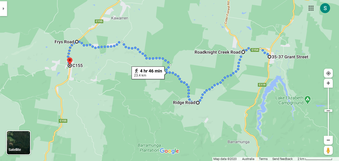
Forrest to Gellibrand 24km
Terrain: Hilly to undulating and no services or water. A mixture of tracks and roads and a lovely section through forests with little traffic but it is a logging area. The roads where logging trucks travel are marked with a numbering system on posts, so take care and listen for them on any of these roads .
Shorten: There are no public transport options, but there is a taxi service operating out of Colac. Ph. 132227. Or talk to your accommodation about options.
Cycling: Follow the route outlined.
Click here to download detailed directions (PDF)
Shorten: There are no public transport options, but there is a taxi service operating out of Colac. Ph. 132227. Or talk to your accommodation about options.
Cycling: Follow the route outlined.
Click here to download detailed directions (PDF)

From Forrest
|
To Gellibrand
(355m-79m) |
Points of interest:
Gellibrand River Gallery: Contemporary art and photography by local artists.
Pick your own strawberries: at Otway Strawberries.
Old Beechy Rail Trail
Click here to find out what facilities and accommodation are available in the towns.
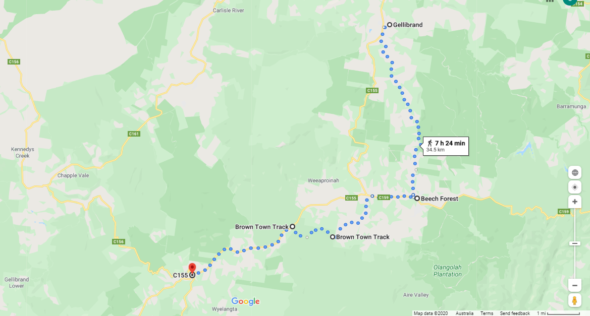
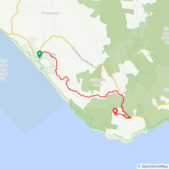
Gellibrand to Beech Forest (14km) to Lavers Hill 34km
The Brown Town Track (3-4km) of this section has not been trialed or proven.
Terrain: Mostly gravel and dirt trails with a mixture of bush/forest and open fields. Part of this continues on the Old Beechy Rail Trail, and sections on the Old Beech Forest Road with a fairly long climb into Beech Forest. Then onto the Colac-Lavers Hill Road so watch out for logging trucks. Brown Town Track is a seasonally gated track and Parks Victoria advise it is possible to walk it despite quite a bit of damage from 4WD vehicles. The state of the track may be affected by weather conditions. There are no shops in Beech Forest, but an excellent country pub with accommodation and meals.
Shorten: There are no public transport options, but there is a taxi service operating out of Colac. Ph. 132227. Or talk to your accommodation about options. There are a couple of accommodation options in Beech Forest so you may choose to have an extra night's stop in this lovely area.
Cycling: It is not possible to cycle Brown Town Track so once departing Beech Forest stay on the Colac-Lavers Hill Road for this whole stretch. If cycling, the Old Beechy in some sections can be soft and technically difficult for bikes so it is suggested staying on the road that runs parallel to the trail. Read more detailed information on the trail on https://www.colacotway.vic.gov.au/Parks-Recreation/Old-Beechy-Rail-Trail
Click here to download detailed directions (PDF)

From Gellibrand
|
To Lavers Hill
(538m-92m) |
Points of interest:
Waterfalls: Triplet Falls is in the area but requires a short detour to visit.
Otway Fly Treetop Adventures: Book a zipline or a walk in the treetops.https://www.otwayfly.com.au/
Old Beechy Rail Trail: From Gellibrand to Ferguson through Beech Forest.
Lavers Hill: A town at the convergence of several roads including the Great Ocean Road so it can have a high through traffic.
Click here to find out what facilities and accommodation are available in the towns.
Lavers Hill to Wattle Hill
There are two (2) ways to travel this section:
A: One day direct to Wattle Hill on the Great Ocean Road (17km), or;
B: Two days returning to the Great Ocean Walk at Johanna (30km).
A: One day direct (17km)
Terrain: All of this is on the Great Ocean Road. Whilst it is a quieter section than the parts running along the coast, it does carry quite a bit of traffic and has very little to no verge for the most part. Not a pleasant walk, despite it having some nicely forested sections and farmlands. There are no services.
Shorten: There are no public transport options, but there is a taxi service operating out of Colac. Ph. 132227. Or talk to your accommodation about options. There are however accommodation options in Yuulong along this stretch before Wattle Hill so you could choose to take an extra stopover.
Cycling: Follow the route indicated.
Click here to download detailed directions (PDF)

From Lavers Hill
|
To Wattle Hill
(460m-193m) |
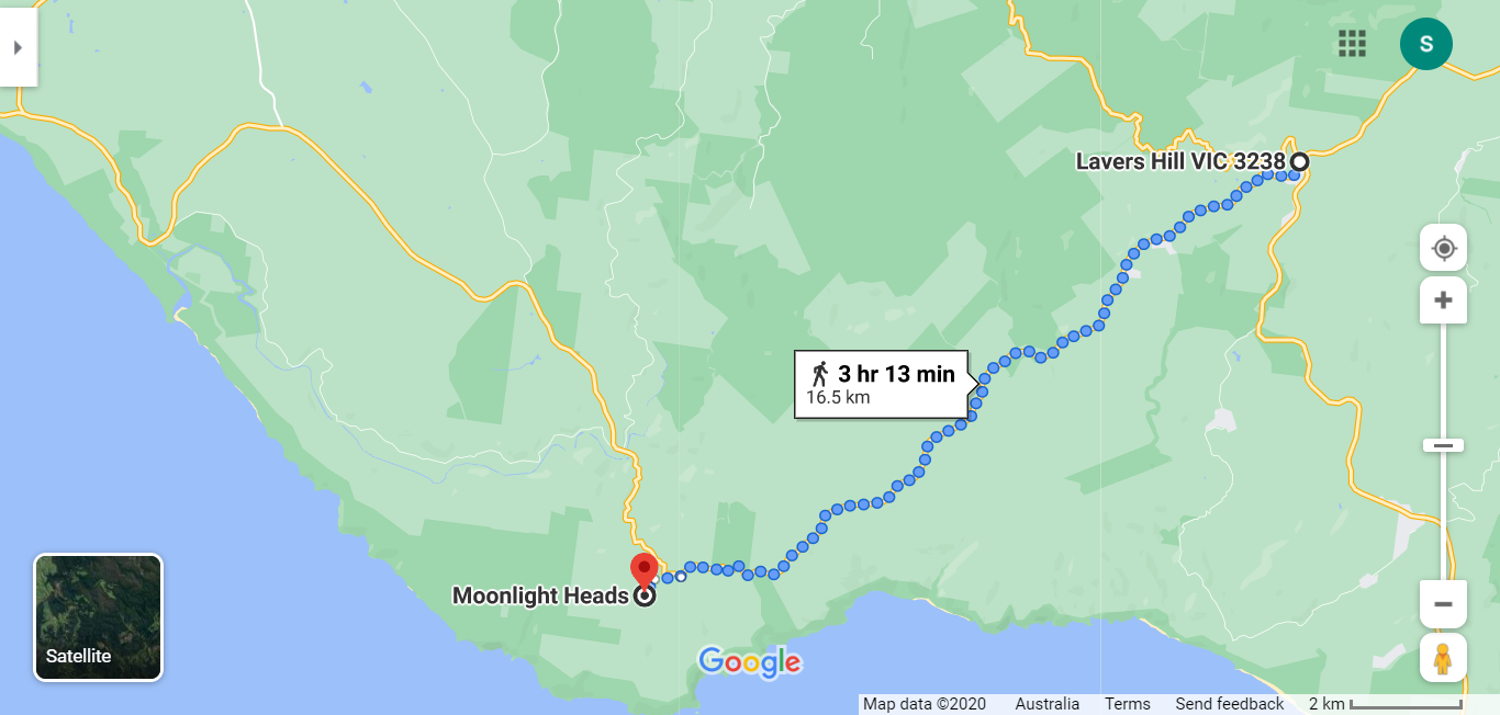
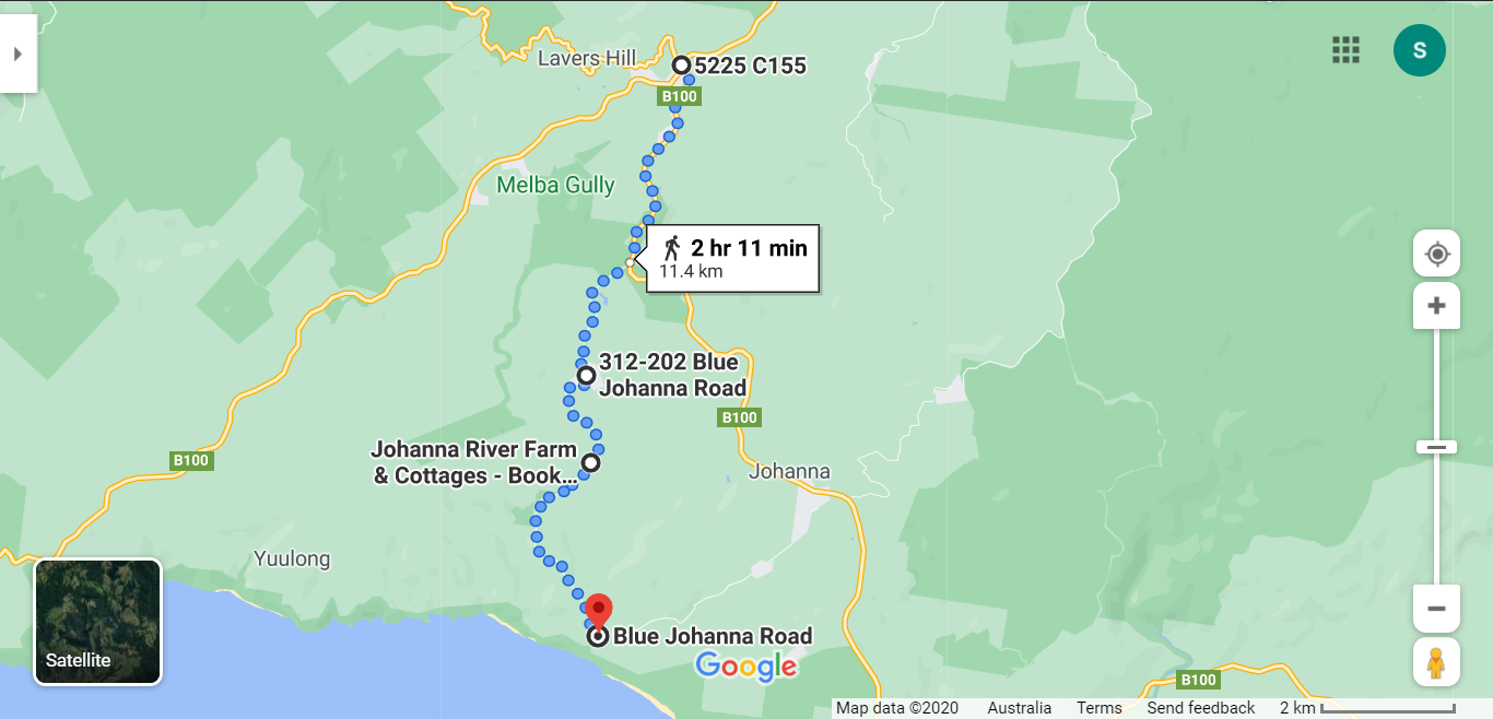
A: Two days via Johanna (32km)
This section has not been completely trialed or proven.
Terrain: Day one of this is short (7-12km) and all downhill to the next accommodation, firstly on a short section of the GOR then a mostly sealed winding road to Johanna Beach to pick up the Great Ocean Walk. There are a number of accommodation options at varying distances apart on this stretch, but remember, the further you walk this day, the shorter the 2nd day will be. Day 2 is longer and very hard as it goes up and down to ridges and gullies (20-25km).This section of the Great Ocean Walk is classified as Hard.
The maps provided below show the connections to meet up with the GOW and the small section to leave the GOW to accommodation in Wattle Hill.
Shorten: There are no public transport options, but there is a taxi service operating out of Colac. Ph. 132227. Access with a vehicle is not possible after Johanna Beach. Or talk to your accommodation about options.
Cycling: It is not possible to cycle this option.
Click here to download detailed directions to Johanna (PDF) and here from Ryans Den (PDF)

From Lavers Hill to Johanna Beach 459m-21m
|

From Ryans Den to Wattle Hill 44m-215m
|
Points of interest:
Bushland and open farm country .
Bushland and open farm country .
Click here to find out what facilities and accommodation are available in the towns.
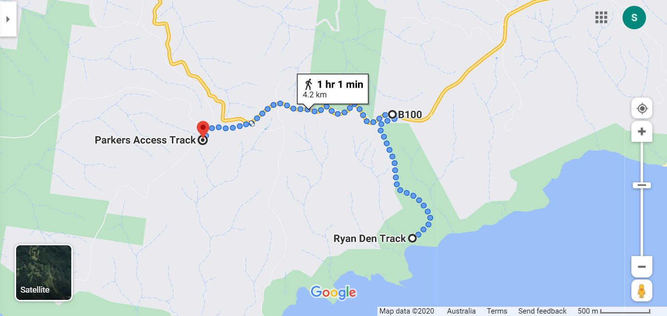
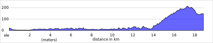
Wattle Hill to Princetown 14km
Terrain: Coastal cliffs, gullies and dune systems on our way back to the coast and the Great Ocean Walk Track. There are a couple of options for this section. Head north to Moonlight Head Road and follow this down to again pick up the Great Ocean Walk near the Gables carpark. This will take you into Princetown. There is an alternative route at this point which will take you via the Gables and Wreck Beach but whilst this option takes in some spectacular coastline it is a slightly longer and harder route. The map shows the route via the Old Coach Road which is the shortest and flatest route into Princetown. It runs parallel to and intersects occasionally with the GOW.
Cycling: It is not possible to ride along the GOW so an alternative map is provided using RidewithGPS from West to East.
Shorten: No public transport options in this section.
Click here to download detailed directions (PDF)
Cycling: It is not possible to ride along the GOW so an alternative map is provided using RidewithGPS from West to East.
Shorten: No public transport options in this section.
Click here to download detailed directions (PDF)
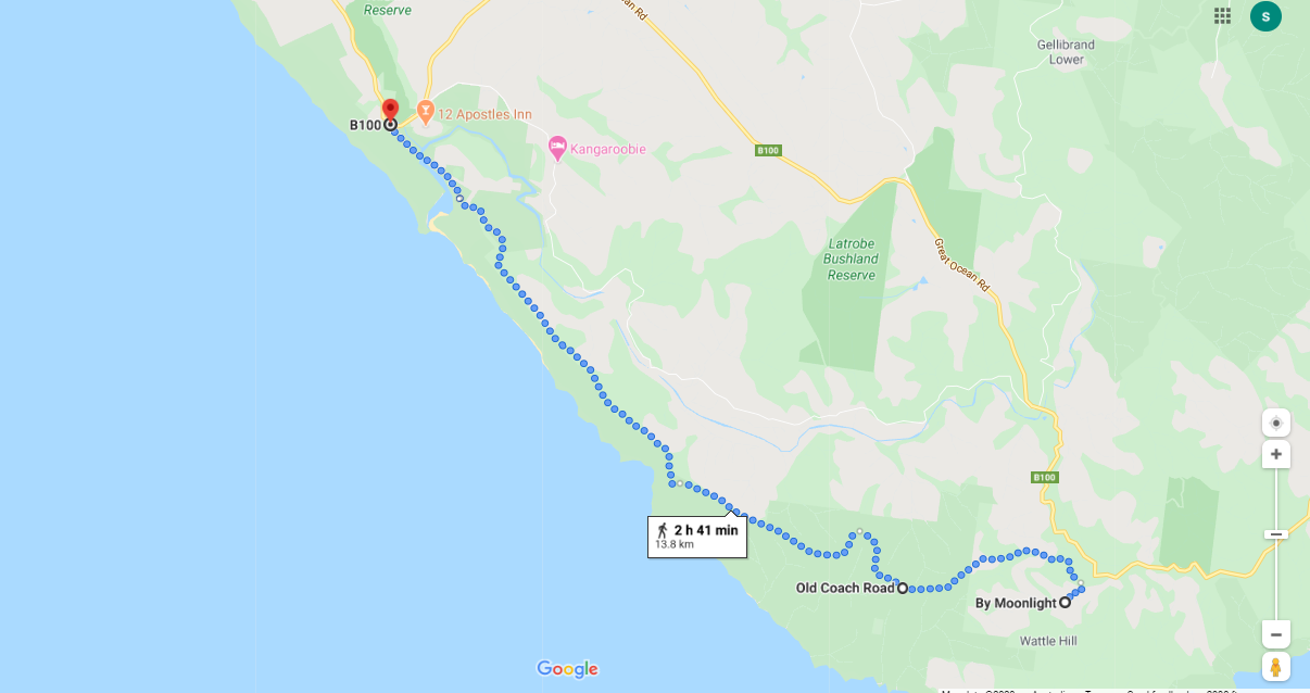

From Wattle Hill
|
To Princetown
(209m-3m) |
|
Cycling West to east - Princetown to Wattle Hill
Click here for printable cue sheet (PDF) |
Points of interest:
Coastal views: At all the points along the GOW.
Marshland and dune systems: particularly on Old Ocean Road as it follows the Gellibrand River.
Coastal views: At all the points along the GOW.
Marshland and dune systems: particularly on Old Ocean Road as it follows the Gellibrand River.
Click here to find out what facilities and accommodation are available in the towns.
Great Ocean Road Information:
The speed limit on this section of the Great Ocean Road is a maximum of 80kmh with many sections being between 20-40kmh It can be unsafe for pedestrians or cyclists. Although some sections have a reasonable verge, others have none at all and are quite narrow.
The distance from Aireys Inlet to Apollo Bay on GOR is 63km and accommodation is available at Lorne (18km); Wye River (18km); Kennett River (6km); Skenes Creek (17km); Apollo Bay (6km) and various intermittent locations in between.
It is possible to do some parts along the beaches, but be careful not to go down to the sand and walk the beach unless you are sure you can get back up again or you will have to backtrack. It is possible to walk down to the beach and back up again using beach or walking paths for approximately 22km of this roadway in the following locations:
Apollo Bay to the end of Fairhaven Beach - 6.5km
Lorne to St Georges River via the Lorne Foreshore, Shipwreck Trail and Tramway Track Trail - 6km
Separation Creek to the end of Wye River Beach - 1.5km
Kennett River Bridge to Kennett River Surf Life Saving Club - 500m
Carisbrook Creek to Onion Bay - 2km (not at high tide)
Skenes Creek to Apollo Bay - 5.5km
